 |
| The Kentucky Bend |
There are examples of exclaves all over the world, and they tend to exist in locations where geography, history, and politics have combined to leave a portion of a state or nation where you wouldn’t expect it to be. The stories behind these exclaves are often interesting, and common sense may suggest that they not exist. Why isn’t the Kentucky Bend part of Tennessee, or even Missouri [3]?
First, what am I calling an exclave? Definitions vary, but to me exclaves are geographic areas of one state or country that are physically separated from the bulk of their home state/country, requiring transit through (or over) another state/country, unless the separated place can be accessed via the open sea. If you can’t drive or walk or ride or fly or sail there without going through another place, it's an exclave. By this definition, Alaska isn’t an exclave of the United States. Sure it’s physically separated from the rest of the country, but planes and ships can transit between the “lower 48” and Alaska without going through Canadian territory. In the same vein, Hawaii, or any other island distant from the mainland, isn’t an exclave.
Consider a few prominent examples (of dozens) of true exclaves from around the globe:
Straight Lines
A ninth-grade biology or Earth sciences student could tell you that nature doesn’t use straight lines; however, mankind loves them. Just compare man’s architecture to nature’s landscapes. As a consequence, our un-straight Earth, where even the flat horizon of a dead calm sea creates a circle, is divided into political units by straight lines drawn on flat maps. When this happens sometimes you end up with unexpected results. The U.S./Canadian border provides a great illustration of this point.
 |
| Point Roberts, Washington |
- Point Roberts, Washington on the Strait of Georgia and connected by land only to British Columbia.
- Elm Point and Northwest Angle, Minnesota in the Northwest Angle of Minnesota but connected by land only to Manitoba.
- Province Point and Alburg, Vermont on Lake Champlain but connected by land only to Quebec.
- Saint Regis, Quebec on the St. Lawrence River but connected by land only to New York.
- Campobello Island, New Brunswick which is only connected to land, via a bridge, to Maine.
A glance at the map shows that these places would more logically be part of the nations that they are physically attached to. But politics and history means that will never come to pass.
Straight lines similarly separate most U.S. states and Canadian provinces, creating exclaves in both countries. A few of note:
- Knott’s Island, North Carolina which is actually connected by land to Virginia.
- Eastern Shore of Virginia which is separated from the rest of the state by the lower Chesapeake Bay and connected by land to Maryland. However, its exclave status was largely eliminated when the Chesapeake Bay Bridge-Tunnel was completed in 1964, which now connects the eastern shore across the mouth of the Chesapeake Bay to Virginia Beach.
- Lost Peninsula of Michigan, which is actually connected by land only to Ohio.
- Cold Lake, Alberta where a spit of land near the town is actually connected by land only to Saskatchewan.
The March of History
 |
| Colorful West Berlin |
Keeping in this part of the world, a current exclave is the Russian territory of Kaliningrad, which is separated from the rest of Russia by the Baltic States and Belarus. Of course during most of the year Kaliningrad, home to the Russian Baltic Fleet, is connected to the home country via the sea. However, during winter all other Russian Baltic posts are frozen over, which makes Kaliningrad (itself ice-free) a true winter exclave. Looking historically, a reverse of this existed between the two World Wars when East Prussia was physically separated from the rest of Germany by Poland.
The southernmost state of the Netherlands is Zeeland, and its south section, Zeelandic Flanders, is located on the south bank of Scheldt River is connected by land only to Belgium. For much of its history it was in fact part of Flanders and not a Dutch state. It was incorporated into the Dutch Republic in the seventeenth century and more formally incorporated into the country after the second fall of Napoleon in 1815. As a part the Netherlands, it’s technically an exclave. However, there is a new tunnel that provides vehicle access across the Scheldt to the rest of the country.
One could argue that Istanbul, and all of European Turkey, is an exclave separated from the rest of Asia Minor, but I don’t think it qualifies because the Bosporus is narrow and crossed by two bridges. Similarly, the Spanish cities of Ceuta and Melilla, located along the Moroccan coast, are considered exclaves but they do have access to the sea and are located just across the Strait of Gibraltar from the Spanish mainland. Perhaps Gibraltar is more of an exclave being far removed from Britain.
Looking away from Europe and North America, a small portion of Bolivia, Copacabana located on Lake Titicaca, is geographically separated from the rest of the country, being connected by land to Peru. Armenia and Azerbaijan have exclaves of the other nation within (or between) their own territory.
Shifting Shores
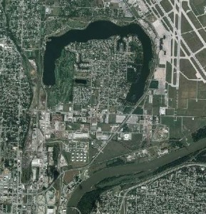 |
| Carter Lake - note the residual oxbow lake left when the Missouri shifted |
Enclaves
While discussing exclaves, I may as well mention the opposite, the enclave, places like Vatican City or Lesotho that are completely surrounded by another nation. At a local level, many cities surround and make enclaves of separate, smaller communities [5]. Yet more examples of fascinating ways that humans have found to delineate our world.
---
NOTES:
[1] Or horseshoe-shaped, or oxbow shaped, whatever you prefer.
[2] In this case a sub-national exclave.
[3] There appears to have been general confusion – 200 years ago – about the exact geography of the Mississippi River near the confluence of the Ohio and how and what should have been surveyed as part of Kentucky.
[4] Over 5,500 miles long.
[5] Like how Beverly Hills is completely surrounded by Los Angeles.
No comments:
Post a Comment